
Well, here it is kids. I've finally stepped up from the spartan (yet popular) TrailJournals.com, to posting on a graphic-intensive blog. I will be updating this sporadically while I plan for my upcoming 5 month backpacking trip, and then routinely while I am out doing my 'thang'.
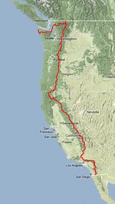
Looking at the map over there, you can see my route starting at the Mexican/US border in Campo, CA and ending at Cape Flattery, WA. "But how are you going to do that Eric"? Good question. I'll start hiking north on the Pacific Crest Trail (PCT) on April 24th. 4.5 months and 2,667 miles later, I'll finish the PCT at it's northern terminus at the Canadian border in Manning Provincial Park. From here, I'll turn around, and hike 17 miles southbound until I hit the junction with the rarely used Pacific Northwest Trail (PNT). Here I turn west, and head 500+ miles to the Pacific Ocean off of Olympic National Park. The PNT follows the western coast for a few days, and ends at the westernmost point in the lower 48 at Cape Alava. I am planning on hiking 15 miles further north to end at the northwest tip of the Olympic Peninsula, Cape Flattery.
What will I see on this hike? A Sonoran high-desert that is known to have snow on high peaks. I can go from 110 degree weather in low elevations to below freezing and deep snow in the San Jacintos of Southern California. There are multiple 30+ mile waterless stretches through the Sonoran and Mojave deserts. Once out of the desert, I enter what is often considered the most scenic hiking in the U.S....the High Sierras. This area includes Yosemite, Sequoia, Ansel Adams, and Kings Canyon parks. This is a pristine wilderness stretching over 200 miles, all without crossing a single road. I will be carrying 10 days of food in my pack, allowing me to go over a week without entering a town to really get a feel for these beautiful mountains and alpine meadows. For kicks, I'll make a side trip up Mt Whitney, the tallest mountain in the lower 48. In Northern California, Oregon, and Washington, the trail passes numerous extinct volcanoes including the mythical Shasta, Hood, and Rainier. The final stretch of the PCT goes through the beautiful, expansive Pasatyan wildnerness.
Heading west, I get out of the Pasatyan wilderness at Ross Lake, which I hope to cross by motor boat to pick up a resupply package. Eventually I have to hike along a few islands off of the western coast, then take a ferry to get into Olympic National Park. Here I hike west until hitting the far Pacific Coast, and finally a few days of hiking along to the coast to get to the western terminus. These days of coastal hiking will be a new challenge for me since they require the use of tide charts to navigate around high tide. When high tide swallows the hiking trails, I'll retreat upland and watch the powerful Pacific until the waves subside. This section is known for it's beachcombing, whales, and seals. Although the PNT ends at Cape Alava, I want to hike another day and a half north to pass the legendary Shi Shi beach, a surf-bum favorite, and damn dramatic. Once i get to Cape Flattery, I'll have to hitchhike through Neah Bay, a Native American reservation, to get to an airport and fly home.
What a trip, and one that will surely match and maybe eclipse my adventures on the Appalachian Trail in 2007.
Monday, January 21, 2008
Subscribe to:
Posts (Atom)