
When I chew on my couscous dinners at night, sand crunches between my teeth. My camera lens grinds when I shut it because of sand. If I take my earbuds out of my ears after listening to music, they are covered in sand. Sand is everywhere.
The high desert is an amazingly varied place. I have come to the realization that every canyon has it's own character. Yesterday after leaving Cajon Pass, hiking through the San Andreas Rift Region then through the freakish Mormon Rocks, I saw the greenest canyon I've seen yet. I didn't think much water ran through the area, but there were actually trees on the side of this low elevation canyon. After climbing about 1000 feet, and snaking around to the other side of the mountain, it was all sparse chapperal. Fun. I climbed uphill for hours, finally reached a jeep road and cooked dinner over my woodstove. The plan was to hike another mile or so to find a nice soft spot with pine needles for cushion since I'm using a really thin sleeping pad, but plans never stick with me. I got inspired out of nowhere and decided to nighthike all the way to the road crossing where I"d hitch into this town, Wrightwood. That was 12 miles, a fullish moon at Waxing Gibbous, and no need for a headlamp to see ahead of me. The hiking was slightly sketchy, nearly losing the trail at a few road crossings and at a strange ski resort, finally making it to the road to sleep at 1 am. I slept on the side of the road, which receives no traffic at night. I woke up 5 hrs later to an awesome sunrise over Mt Balden-Powell, which still has lots and lots of snow. I'll be climbing up this tomorrow, hopefully to the peak to get a view of Death Valley, miles and miles away. Now it's time to find one of the local trail angels who take in hikers, for a MUCH needed laundry session. Rinsing in lakes and streams just doesn't cut it for a white shirt in the socal desert.
Thursday, May 15, 2008

Monday, May 5, 2008
Road-walkin' the PCT
What a rough stretch of days. I managed to get sick somehow in Warner Springs, sidelining me for another day. I decided to take off the next day with only a few slices of bread in my stomach over the past 24 hrs. Bad mistake, as any reader could predict. Even though I was feeling better than I was in the past 2 days, I wasn't ready for hiking. I was tired, dehydrated, etc etc. I didn't enjoy the first 17 mile day until I got to the spot I would be camping.
The spot I was camping was trail angel Mike's place. Mike is a local who lets you walk .25 mi down a dirt road, take water from his spigot when he's not even there, and even has a screened in patio that thru-hikers can sleep in. I got here and found 4 other hikers there. Greybeard, Ross (Naugty Eyes), Gopher (who I met last year on the AT), and others I barely noticed in my sickened state. We all sat around goofing around, and I was able to somehow eat a cup of Ramen noodles, which Mike left behind for hikers to eat. See, I've been having a problem eating any of my trail food. It was either too sweet or too bland.
Next day was a bit worse, but I managed to pound out 10 miles by lunch time. After sharing some shade with Ryan, Gopher, and Greybeard, I pushed on in the 90+ deg heat, desperately trying to make it to the Paradise Cafe, 14 miles further! I made it 7 more miles to a water cache, and had to fold it in there. I wasn't able to force any food down the stomach, was having terrible stomach cramps, and decided the smart decision would be to chill for the rest of the day. It was around 3:00, an early time to stop hiking.
I spent the rest of the afternoon talking to Lucky about his state of Michegan, Hawaii, and our hikes of the A.T. I gathered a bit of fuel for fire, which is plentiful here in socal with dead chapperal branches everywhere. I tried to enjoy some spaghetti, then called it a night, without even writing in my journal, which is rare.
The next day I awoke, feeling healthy and ready to hike. Still, I knew I had only 10 miles to hike so I stayed in bed a bit and waited for the sun to heat up the 36 degree air. In the meantime I listened to my mp3 player that I received in Warner Springs. Sweet bliss. When I got moving, hiking had never felt so good. I had an absurd amount of energy. I took frequent breaks when there were enormous boulders to be photographed, or insanely steep, sandy slopes magically holding up tall, purple-flowering plants. Finally I was able to make it down to the valley, and the road crossing.
At the road was another hiker from years past, Tarzan. Tarzan had a huge canopy setup for shade, and was waiting for hikers so that he could feed us his famous Lintel soup and lemonade. good stuff and I sat there for 5 hrs getting some rest.
When I was ready to move on, I hiked another mile west along the road to the Paradise Cafe. I was joined by GoodTimes and a Swiss couple. At this cool, friendly, dive of a bar, I made sure to order their legendary Jose Burger. This was an amazing burger, a burger topped with bacon, swiss cheese, avacado, and mushrooms.
I managed to pull myself away from the crowd, and told myself I would road walk a few miles before dusk set in in 2 hrs. I should say that the trail has been closed for 50 miles due to wildfire. PCT thru-hiker induced wildfire. Apparently a brilliant hiker got the idea to put his ciggarette out in a dead tree stump, then 400 acres went ablaze. Now we either road walk if you are a purist about walking north the whole way, or hitchike this roadwalk. Its 18 miles. 18 miles is a long way to walk on a road. A road without a shoulder. And blind curves.
The first 6 miles actually had a wide shoulder, and this I used until I found a fantastic camping spot 5 miles in. I slept surpisingly well in my sleeping quilt rated to 45 degrees, although it was 21 degrees out. My alarm was set for 5 am, to beat the rush hour traffic. I hiked as hard as I could to get off that damned road, and it took me until 9 to finish those 11 or so miles.
Just before town I met a really cool cyclist named, lets say John. He was cycling from Sacramento to Tijuana, and now back home in Sacramento. He had also cycled west from coast to coast in the US, from Canada to Mexico along the Continetal Divide, and even more impressively to me, from Prudhoe Bay to Homer, in Alaska. Great guy and it was fun to talk to a long-distance cyclist, something I have interest in myself.
Now I'm in town, caught up with friends at a cheap campground in town, showered (still not clean!!!), clean laundry, and stuffed with french toast, eggs, sausage, and a cinnamon roll. Life is good in the cool, small, mountain town of Idyllwild.
The spot I was camping was trail angel Mike's place. Mike is a local who lets you walk .25 mi down a dirt road, take water from his spigot when he's not even there, and even has a screened in patio that thru-hikers can sleep in. I got here and found 4 other hikers there. Greybeard, Ross (Naugty Eyes), Gopher (who I met last year on the AT), and others I barely noticed in my sickened state. We all sat around goofing around, and I was able to somehow eat a cup of Ramen noodles, which Mike left behind for hikers to eat. See, I've been having a problem eating any of my trail food. It was either too sweet or too bland.
Next day was a bit worse, but I managed to pound out 10 miles by lunch time. After sharing some shade with Ryan, Gopher, and Greybeard, I pushed on in the 90+ deg heat, desperately trying to make it to the Paradise Cafe, 14 miles further! I made it 7 more miles to a water cache, and had to fold it in there. I wasn't able to force any food down the stomach, was having terrible stomach cramps, and decided the smart decision would be to chill for the rest of the day. It was around 3:00, an early time to stop hiking.
I spent the rest of the afternoon talking to Lucky about his state of Michegan, Hawaii, and our hikes of the A.T. I gathered a bit of fuel for fire, which is plentiful here in socal with dead chapperal branches everywhere. I tried to enjoy some spaghetti, then called it a night, without even writing in my journal, which is rare.
The next day I awoke, feeling healthy and ready to hike. Still, I knew I had only 10 miles to hike so I stayed in bed a bit and waited for the sun to heat up the 36 degree air. In the meantime I listened to my mp3 player that I received in Warner Springs. Sweet bliss. When I got moving, hiking had never felt so good. I had an absurd amount of energy. I took frequent breaks when there were enormous boulders to be photographed, or insanely steep, sandy slopes magically holding up tall, purple-flowering plants. Finally I was able to make it down to the valley, and the road crossing.
At the road was another hiker from years past, Tarzan. Tarzan had a huge canopy setup for shade, and was waiting for hikers so that he could feed us his famous Lintel soup and lemonade. good stuff and I sat there for 5 hrs getting some rest.
When I was ready to move on, I hiked another mile west along the road to the Paradise Cafe. I was joined by GoodTimes and a Swiss couple. At this cool, friendly, dive of a bar, I made sure to order their legendary Jose Burger. This was an amazing burger, a burger topped with bacon, swiss cheese, avacado, and mushrooms.
I managed to pull myself away from the crowd, and told myself I would road walk a few miles before dusk set in in 2 hrs. I should say that the trail has been closed for 50 miles due to wildfire. PCT thru-hiker induced wildfire. Apparently a brilliant hiker got the idea to put his ciggarette out in a dead tree stump, then 400 acres went ablaze. Now we either road walk if you are a purist about walking north the whole way, or hitchike this roadwalk. Its 18 miles. 18 miles is a long way to walk on a road. A road without a shoulder. And blind curves.
The first 6 miles actually had a wide shoulder, and this I used until I found a fantastic camping spot 5 miles in. I slept surpisingly well in my sleeping quilt rated to 45 degrees, although it was 21 degrees out. My alarm was set for 5 am, to beat the rush hour traffic. I hiked as hard as I could to get off that damned road, and it took me until 9 to finish those 11 or so miles.
Just before town I met a really cool cyclist named, lets say John. He was cycling from Sacramento to Tijuana, and now back home in Sacramento. He had also cycled west from coast to coast in the US, from Canada to Mexico along the Continetal Divide, and even more impressively to me, from Prudhoe Bay to Homer, in Alaska. Great guy and it was fun to talk to a long-distance cyclist, something I have interest in myself.
Now I'm in town, caught up with friends at a cheap campground in town, showered (still not clean!!!), clean laundry, and stuffed with french toast, eggs, sausage, and a cinnamon roll. Life is good in the cool, small, mountain town of Idyllwild.
Wednesday, April 30, 2008
115 degrees is nothin'
Southern California is beautiful. Fact.
I've had a great time out here so far. I've hiked for 5.5 days, and am taking a day and a half off at the resort of Warner Springs. They give hikers a ridiculous discount in their normally $155/night adobe houses. Going to soak in the hot springs a few times today to try to help my blistered feet.
Let's talk about hiking. I started at the border with about 20 other people and did 21 miles to Lake Morena. I met lots of really great people that first day of hiking. The hiking was very easy, and before I Knew it, I had taken a long 1 hr break in some rare shade at the bottom of a canyon under some Oaks, then strolled into the campground before 5. Strange. The trail was really sandy at first, almost like the beach. There are lots of remnants left by immigrants. Turns out immigrants use the PCT a lot to sneak through the area. They wear socks over their shoes to avoid putting footprints in the sand, and you find big stashes of socks, or blankets with ropes, littering the trail. Not much cactus, but lots of the cool yucca plants, large boulders, and random oak trees as I hiked the small hills that lead to larger mtns further north.
I left the Lake on Friday morning, by myself. Everyone else was staying for the huge, 800 Person kickoff party, which left the trail all to myself for the next 2 days. My antisocial tendencies rewarded me with an amazing section of trail, and the occasional company of a dayhiker. I met a couple of ultramarathon runners, and it was inspiring to hear their stories of 50 mile races through these mtns in the May heat. The next 2 days would show me canyons scarred by a huge wildfire back in '03, bigger and bigger mtns, and a jaw-dropping view down into the Colorado desert and Anza-Borrego Desert State Park. I met a couple day hiking on Saturday who said in the summer, when you round the bend, you can feel the heat rushing up from the searing Colorado Desert below, 2000 feet below, and it's crushing. I'm too early in the season to feel that though. Bummer. The temps the first few days were in the 90s.
When I started the trip, I decided to try using an umbrella. I met quite a few other people doing the same. Let me say that I hate using an umbrella. I got a pretty sweet setup to rig the umbrella to my backpack strap, but still, it cuts off a lot of the view around you. Great shade. Even when its 95 out, if feels like 70. Still, I'm out here to become one with the wilderness, not be sheltered on all sides from it. So, on the 3rd day, I stopped into the tiny store at Mt Laguna for another solution. After picking up my resupply box of 3 days of food, I purchased a GINORMOUS straw hat...made in Mexico no less. This thing has worked great, and allowed me to avoid using sunscreen altogether. Couple this with my oversized, long-sleeve white shirt and my long skirt, and I"m very very comfy out there.
The last 2 days saw me hiking in Anza Borrego Desert State Park. The cactus are all flowering now. I saw some staggering displays of poppy fields that are blooming. I'd look out and see a huge rectangular tract of land that was blazing yellow, and everything else around it was dry. It seemed cartoonish and like something out of a childrens book. The east sides of mtns would be scattered with flowers, the other sides dry, and down in the canyon bone dry. Rodriguez Canyon was immense. To the north was San Felipe Valley, also HUGE....it looked like a Great Plain down there, nothing but dirt. 17 miles later I was walking down in the valley to reach the next string of mtns to the north, and turns out there is about 6 different kinds of cactus, all spaced 5 feet apart. I really dug the minimalistic way that the vegetation grows at the really low altitudes. Toward the end of the day I made it to Scissors Crossing, which was stocked with over 80 gallons of water at a cache for hikers. This section through the San Felipe Hills is a legendary one, legendary for being so dry. If there weren't water stocked here, you'd go well over 40 mi without seeing natural water. At this cache, one of the Isreali friends I've been hiking with came down with severe dehydration. Turns out he didn't drink very much through the day, and when he sat down here, he felt nauseated. We gradually got him to drink 1.5 liters of water, some electrolites, and he started to feel ok to walk the last quarter of a mile to camp.
The next day came the San Felipe Hills. This got to a lot of people, including myself. I woke up at 5 am to start hiking before the sun came up to beat the insane heat of these desert hills. There was a long sequence of switchbacks to get out of the valley, but luckily the mtns were all clad in long long shadows to keep me out of the quickly rising sun. The shadows got shorter and shorter, and the drop-offs were steeeper and steeper into the side canyons below. At one point an Air Force plane shot overhead. I ducked to the ground, having no clue what the sound was. In my insane state, I thought it was some impossibly hard gust of wind that would take me to the ground. I have seen some intense gusts of wind, one took my hat off, even though it was sinched to my chin as tight as I could get it, leaving me sprinting for it before it got taking into the canyon below. That plane just snuck over the ridge above me, that ridge blocking the sound of the oncoming plane. I had to laugh at myself afterward, and let out a scream of relief.
After 13 miles, I found another water cache at the top of the mtn. I sat down in the small amt of shade there was for about an hr, with about 7 other hikers. We cracked jokes, I wrote in my journal, and soon we were off to hike again. Before I packed up, I noticed a reading of 115 degrees in the sunshine. I knew it was hot, but had no clue it was that hot. Amazing. the last 10 miles were the longest of my hike. I'm not sure what got to me. It was beautiful slowly winding down the mtn. You could look back and see the last half of a mile that you came from slicing along the mtn, and look north and see where you were going. There were an infinte amt of side canyons and gullies, and somewhere in there I got frustrated and couldn't figure for the life of me where I was on the map. All of the side canyons were eroded in the same direction off the mtn. In hindsight it was all so ridiculous, but at the time I really wanted to know how much further I had to hike. Couple that with the fact that I was getting more and more blisters in that insane heat, and it was a long trip down.
When I got to the bottom, another hiker Running Feather, was waiting with a watermellon someone had given him. Man was that a good watermellon. Slept terribly that night with my ultralight, thin, sleeping pad. One of these days I'll toughen up again to sleeping on the ground, but sleeping on a mattress the past 6 months really ruined me.
I hiked another 8 miles through really gentle foothills to get to Warner Springs. Once I got here I found a ton of hikers I'd never met. All had gotten sucked into the vortex of this resort, and stayed a day longer than they intended. I'll see these guys up ahead, probably at the next town stop of Idylwild.
Sorry for the lack of pictures. I've already taken over a hundred, but there is no way to upload them here.
I've had a great time out here so far. I've hiked for 5.5 days, and am taking a day and a half off at the resort of Warner Springs. They give hikers a ridiculous discount in their normally $155/night adobe houses. Going to soak in the hot springs a few times today to try to help my blistered feet.
Let's talk about hiking. I started at the border with about 20 other people and did 21 miles to Lake Morena. I met lots of really great people that first day of hiking. The hiking was very easy, and before I Knew it, I had taken a long 1 hr break in some rare shade at the bottom of a canyon under some Oaks, then strolled into the campground before 5. Strange. The trail was really sandy at first, almost like the beach. There are lots of remnants left by immigrants. Turns out immigrants use the PCT a lot to sneak through the area. They wear socks over their shoes to avoid putting footprints in the sand, and you find big stashes of socks, or blankets with ropes, littering the trail. Not much cactus, but lots of the cool yucca plants, large boulders, and random oak trees as I hiked the small hills that lead to larger mtns further north.
I left the Lake on Friday morning, by myself. Everyone else was staying for the huge, 800 Person kickoff party, which left the trail all to myself for the next 2 days. My antisocial tendencies rewarded me with an amazing section of trail, and the occasional company of a dayhiker. I met a couple of ultramarathon runners, and it was inspiring to hear their stories of 50 mile races through these mtns in the May heat. The next 2 days would show me canyons scarred by a huge wildfire back in '03, bigger and bigger mtns, and a jaw-dropping view down into the Colorado desert and Anza-Borrego Desert State Park. I met a couple day hiking on Saturday who said in the summer, when you round the bend, you can feel the heat rushing up from the searing Colorado Desert below, 2000 feet below, and it's crushing. I'm too early in the season to feel that though. Bummer. The temps the first few days were in the 90s.
When I started the trip, I decided to try using an umbrella. I met quite a few other people doing the same. Let me say that I hate using an umbrella. I got a pretty sweet setup to rig the umbrella to my backpack strap, but still, it cuts off a lot of the view around you. Great shade. Even when its 95 out, if feels like 70. Still, I'm out here to become one with the wilderness, not be sheltered on all sides from it. So, on the 3rd day, I stopped into the tiny store at Mt Laguna for another solution. After picking up my resupply box of 3 days of food, I purchased a GINORMOUS straw hat...made in Mexico no less. This thing has worked great, and allowed me to avoid using sunscreen altogether. Couple this with my oversized, long-sleeve white shirt and my long skirt, and I"m very very comfy out there.
The last 2 days saw me hiking in Anza Borrego Desert State Park. The cactus are all flowering now. I saw some staggering displays of poppy fields that are blooming. I'd look out and see a huge rectangular tract of land that was blazing yellow, and everything else around it was dry. It seemed cartoonish and like something out of a childrens book. The east sides of mtns would be scattered with flowers, the other sides dry, and down in the canyon bone dry. Rodriguez Canyon was immense. To the north was San Felipe Valley, also HUGE....it looked like a Great Plain down there, nothing but dirt. 17 miles later I was walking down in the valley to reach the next string of mtns to the north, and turns out there is about 6 different kinds of cactus, all spaced 5 feet apart. I really dug the minimalistic way that the vegetation grows at the really low altitudes. Toward the end of the day I made it to Scissors Crossing, which was stocked with over 80 gallons of water at a cache for hikers. This section through the San Felipe Hills is a legendary one, legendary for being so dry. If there weren't water stocked here, you'd go well over 40 mi without seeing natural water. At this cache, one of the Isreali friends I've been hiking with came down with severe dehydration. Turns out he didn't drink very much through the day, and when he sat down here, he felt nauseated. We gradually got him to drink 1.5 liters of water, some electrolites, and he started to feel ok to walk the last quarter of a mile to camp.
The next day came the San Felipe Hills. This got to a lot of people, including myself. I woke up at 5 am to start hiking before the sun came up to beat the insane heat of these desert hills. There was a long sequence of switchbacks to get out of the valley, but luckily the mtns were all clad in long long shadows to keep me out of the quickly rising sun. The shadows got shorter and shorter, and the drop-offs were steeeper and steeper into the side canyons below. At one point an Air Force plane shot overhead. I ducked to the ground, having no clue what the sound was. In my insane state, I thought it was some impossibly hard gust of wind that would take me to the ground. I have seen some intense gusts of wind, one took my hat off, even though it was sinched to my chin as tight as I could get it, leaving me sprinting for it before it got taking into the canyon below. That plane just snuck over the ridge above me, that ridge blocking the sound of the oncoming plane. I had to laugh at myself afterward, and let out a scream of relief.
After 13 miles, I found another water cache at the top of the mtn. I sat down in the small amt of shade there was for about an hr, with about 7 other hikers. We cracked jokes, I wrote in my journal, and soon we were off to hike again. Before I packed up, I noticed a reading of 115 degrees in the sunshine. I knew it was hot, but had no clue it was that hot. Amazing. the last 10 miles were the longest of my hike. I'm not sure what got to me. It was beautiful slowly winding down the mtn. You could look back and see the last half of a mile that you came from slicing along the mtn, and look north and see where you were going. There were an infinte amt of side canyons and gullies, and somewhere in there I got frustrated and couldn't figure for the life of me where I was on the map. All of the side canyons were eroded in the same direction off the mtn. In hindsight it was all so ridiculous, but at the time I really wanted to know how much further I had to hike. Couple that with the fact that I was getting more and more blisters in that insane heat, and it was a long trip down.
When I got to the bottom, another hiker Running Feather, was waiting with a watermellon someone had given him. Man was that a good watermellon. Slept terribly that night with my ultralight, thin, sleeping pad. One of these days I'll toughen up again to sleeping on the ground, but sleeping on a mattress the past 6 months really ruined me.
I hiked another 8 miles through really gentle foothills to get to Warner Springs. Once I got here I found a ton of hikers I'd never met. All had gotten sucked into the vortex of this resort, and stayed a day longer than they intended. I'll see these guys up ahead, probably at the next town stop of Idylwild.
Sorry for the lack of pictures. I've already taken over a hundred, but there is no way to upload them here.
Tuesday, April 22, 2008
One day until lift-off

It took me finally finishing up my planning, a bit of nervousness to get me to finally update this blog. The past few months have been stressful, fun, and ultimately will prove to be well worth it once I'm hiking north from Campo come Thursday morning. All the details are set, and I'm going to be taking a flight out of Atlanta at 9:00 am tomorrow, landing in San Diego before noon. This will leave me over 5 hours to wander around the eternally 65 degree weather of San Diego, before being picked up by local trail angels, the Manns. I will be one of 5 hikers staying with the Mann's that night, before being dropped off at the border the following morning.
Before getting into hike specifics, why not rewind?
To condition for my hike, around January I began finally to take running seriously. What started off as 2.4 mile runs, extended to 5, then to 7, and all the way up to 10 miles per day. Once I hit the double digit milestone in my running, I decided to try for a half-marathon. Naturally in my training I managed to increase my mileage too quickly, and developed shin splints and sore knees shortly after hitting the 10 mile mark. I decided to slow things down, starting again from 3 mile runs. I slowly increased the mileage until I could run two 10 mile days a few miles before the race. The race took place in the beautiful city of Albany, GA. The drive down to Albany was really fun and scenic. The race proved to be just as fun. I ran much much faster than I ever dreamt I could do, pushing through sleepy neighborhoods that had trees lining the streets decorated with Spanish moss. The last 2 miles had me running full speed, passing everyone in sight. Ultimately, I finished in the top 50, not bad for my first race. I also met my personal time challenge. A successful weekend for sure. After that race, I never really ran again.
Next up was juggling. I learned how to juggle 3 tennis balls in one weekend.
Then came slacklining. After a few weeks of slacklining, I got a toe caught on the nylon, and awkwardly sprained it. This toe of my left foot is still sore, and worries me about hiking on it when I start the PCT in 2 days. At first just standing on one foot on that wobbly line seemed impossible. I surprised myself though, and was able to stand on one foot by the end of that first day. After a few more days, I was able to take a few steps on the line. A few days later I was walking from one end to the other, then walking backwards back to where I began. Then my bad luck began. My slacking spot at the local elementary school was eliminated when the principal claimed my hobby was too dangerous and she would be held responsible, despite what I considered my own valid arguments. Next they kicked me out of the YMCA trees. Then came my hurt toe. I definitely found some inner peace in those 30 seconds walking the line where the time flowed to what seemed to be 3 minutes. One thing that I'll be looking forward too during this trip will be returning home to get back into slacking again.
Now to the trip planning. I had a heck of a time deciding what backpack to get. Finally I followed my gut, and purchased the Mountain Laurel Designs Zip, which was backordered for nearly 8 weeks. This pack was a beauty, but after too much deliberation, I decided that the volume was too much for me and returned it. After a few more nights of thinking, I decided on a ULA Amp after talking to ULA owner, Brian. Brian agreed to customize the pack for me, and has included wider straps than he normally does on this pack. This will help me infinitely in comfortably carrying the heavy water loads that are essential in the Southern Californian high desert.
Nutrition. For this I actually installed Microsoft Excel to calculate calories to ounce ratios. Nerdy I know, but i really wanted to make the most efficient use of food weight possible. I finally decided on granola with evaporated milk for breakfasts, 4 snacks of a mix of balance energy bars, snickers bars, GORP, pringles, or Wheat Thins. All of these foods range between 130 and 190 calories per ounce. All pretty impressive. Lunches are absurdly delicious peanut butter by Peanut Butter & Co on either whole wheat tortillas or sesame crackers. Dinner is always a base of couscous, with an infinite variety of dehydrated veggies from Harmony House Foods. I even have a desert: dark chocolate, for 220 additional calories. In addition to the better scenery that the PCT will provide, my trip will even more rewarding than my AT experience last year since I'll be eating better for nearly every meal. Variety, good nutrition, and variety.
Now, the pack is packed, my trekking poles and umbrella and stores in a mailing tube, and I'm nervously awaiting my plane ride tomorrow morning. I've said goodbye to all of my friends, my father, and my house plants. At least I can honestly say that I'm as excited to start in the southern Californian desert, as I am about entering what people consider the best hiking in the US, the High Sierra Nevadas.
Talk to ya in a week.
Monday, January 21, 2008
And so it begins...
Well, here it is kids. I've finally stepped up from the spartan (yet popular) TrailJournals.com, to posting on a graphic-intensive blog. I will be updating this sporadically while I plan for my upcoming 5 month backpacking trip, and then routinely while I am out doing my 'thang'.
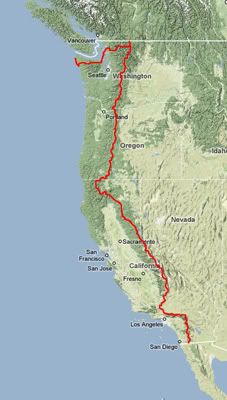
Looking at the map over there, you can see my route starting at the Mexican/US border in Campo, CA and ending at Cape Flattery, WA. "But how are you going to do that Eric"? Good question. I'll start hiking north on the Pacific Crest Trail (PCT) on April 24th. 4.5 months and 2,667 miles later, I'll finish the PCT at it's northern terminus at the Canadian border in Manning Provincial Park. From here, I'll turn around, and hike 17 miles southbound until I hit the junction with the rarely used Pacific Northwest Trail (PNT). Here I turn west, and head 500+ miles to the Pacific Ocean off of Olympic National Park. The PNT follows the western coast for a few days, and ends at the westernmost point in the lower 48 at Cape Alava. I am planning on hiking 15 miles further north to end at the northwest tip of the Olympic Peninsula, Cape Flattery.
What will I see on this hike? A Sonoran high-desert that is known to have snow on high peaks. I can go from 110 degree weather in low elevations to below freezing and deep snow in the San Jacintos of Southern California. There are multiple 30+ mile waterless stretches through the Sonoran and Mojave deserts. Once out of the desert, I enter what is often considered the most scenic hiking in the U.S....the High Sierras. This area includes Yosemite, Sequoia, Ansel Adams, and Kings Canyon parks. This is a pristine wilderness stretching over 200 miles, all without crossing a single road. I will be carrying 10 days of food in my pack, allowing me to go over a week without entering a town to really get a feel for these beautiful mountains and alpine meadows. For kicks, I'll make a side trip up Mt Whitney, the tallest mountain in the lower 48. In Northern California, Oregon, and Washington, the trail passes numerous extinct volcanoes including the mythical Shasta, Hood, and Rainier. The final stretch of the PCT goes through the beautiful, expansive Pasatyan wildnerness.
Heading west, I get out of the Pasatyan wilderness at Ross Lake, which I hope to cross by motor boat to pick up a resupply package. Eventually I have to hike along a few islands off of the western coast, then take a ferry to get into Olympic National Park. Here I hike west until hitting the far Pacific Coast, and finally a few days of hiking along to the coast to get to the western terminus. These days of coastal hiking will be a new challenge for me since they require the use of tide charts to navigate around high tide. When high tide swallows the hiking trails, I'll retreat upland and watch the powerful Pacific until the waves subside. This section is known for it's beachcombing, whales, and seals. Although the PNT ends at Cape Alava, I want to hike another day and a half north to pass the legendary Shi Shi beach, a surf-bum favorite, and damn dramatic. Once i get to Cape Flattery, I'll have to hitchhike through Neah Bay, a Native American reservation, to get to an airport and fly home.
What a trip, and one that will surely match and maybe eclipse my adventures on the Appalachian Trail in 2007.
Looking at the map over there, you can see my route starting at the Mexican/US border in Campo, CA and ending at Cape Flattery, WA. "But how are you going to do that Eric"? Good question. I'll start hiking north on the Pacific Crest Trail (PCT) on April 24th. 4.5 months and 2,667 miles later, I'll finish the PCT at it's northern terminus at the Canadian border in Manning Provincial Park. From here, I'll turn around, and hike 17 miles southbound until I hit the junction with the rarely used Pacific Northwest Trail (PNT). Here I turn west, and head 500+ miles to the Pacific Ocean off of Olympic National Park. The PNT follows the western coast for a few days, and ends at the westernmost point in the lower 48 at Cape Alava. I am planning on hiking 15 miles further north to end at the northwest tip of the Olympic Peninsula, Cape Flattery.
What will I see on this hike? A Sonoran high-desert that is known to have snow on high peaks. I can go from 110 degree weather in low elevations to below freezing and deep snow in the San Jacintos of Southern California. There are multiple 30+ mile waterless stretches through the Sonoran and Mojave deserts. Once out of the desert, I enter what is often considered the most scenic hiking in the U.S....the High Sierras. This area includes Yosemite, Sequoia, Ansel Adams, and Kings Canyon parks. This is a pristine wilderness stretching over 200 miles, all without crossing a single road. I will be carrying 10 days of food in my pack, allowing me to go over a week without entering a town to really get a feel for these beautiful mountains and alpine meadows. For kicks, I'll make a side trip up Mt Whitney, the tallest mountain in the lower 48. In Northern California, Oregon, and Washington, the trail passes numerous extinct volcanoes including the mythical Shasta, Hood, and Rainier. The final stretch of the PCT goes through the beautiful, expansive Pasatyan wildnerness.
Heading west, I get out of the Pasatyan wilderness at Ross Lake, which I hope to cross by motor boat to pick up a resupply package. Eventually I have to hike along a few islands off of the western coast, then take a ferry to get into Olympic National Park. Here I hike west until hitting the far Pacific Coast, and finally a few days of hiking along to the coast to get to the western terminus. These days of coastal hiking will be a new challenge for me since they require the use of tide charts to navigate around high tide. When high tide swallows the hiking trails, I'll retreat upland and watch the powerful Pacific until the waves subside. This section is known for it's beachcombing, whales, and seals. Although the PNT ends at Cape Alava, I want to hike another day and a half north to pass the legendary Shi Shi beach, a surf-bum favorite, and damn dramatic. Once i get to Cape Flattery, I'll have to hitchhike through Neah Bay, a Native American reservation, to get to an airport and fly home.
What a trip, and one that will surely match and maybe eclipse my adventures on the Appalachian Trail in 2007.
Subscribe to:
Posts (Atom)