
For the first time in my life I considered the following: Maybe I should turn back, there are more important things than hiking straight to the ocean like family, friends, and future adventures. Here I was, doing the most intense bushwack of my life up what was surely the steepest slope I've hiked along in my life, with no trail other than what I assumed was ROUGH mountain goat trail to follow.
Everything was going so well before this. I had even begun to think about how I couldn't believe that I was going to make it. All trail would be ahead of me, no nonsense logging roads or 'scratch trails' made by the PNT. The ranger on the phone talked me into a reroute through the Buckhorn Wilderness by roadwalking an unplanned 15 miles down to the town of Quilcene. I had to hike FAST...had 3.5 hrs to hike 14 miles. I didn't think I'd make it, but I made it with time to spare, and felt like I could easily justify my pizza, fries, and strawberry shake. I hiked east a bit and entered the fantastic Buckhorn Wilderness. I followed the Quilcene river upstream until I hit Marmot Pass. Quite a few others had the same idea, and at the top one girl gave me her yogurt pretzls after we exchanged stories. Hers was of travels in South America and how I needed to go, and I told her stories of hiking from Mexico to Canada and now here.
One thing I did not anticipate about this hike is that I would see the seasons changing again. I got to experience beautiful cacti flowering in SoCal, and now at the top of the passes east of the Olympic rainshadow, I was seeing ginormous patches of red and oranges in meadows. I'd hike right next to this low-lying red brush, and when seen across a valley, the sides of each mountain were splashed with red and orange and yellow. Beautiful.
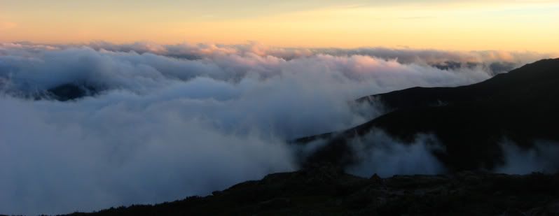
The eastern side of the Olympics were quite dry, which I'm discovering is how I tend to prefer my mountains these days. Very rocky above treeline. Not much undergrowth when actually under trees. The next pass, Constance, was even better. This pass I had entirely to myself to nap on. The view was even better than Marmot Pass, with deep deep valleys below me, and of courses more flourishes of autumn color. The descent was a different story. I had to drop 4,000 feet in about 4 miles. This was definitely the steepest trail I've hiked since the descent to Ross Lake. I ran at least half of it since it was such a pain to hike such a steep slope. That night after getting to the bottom at the Dosewallips River, I camped at a beautiful spot at Lillian Camp.
The next day was the day of Appleton Pass. Things began innocently enough with a gorgeous rainforest walk through the Elwah River Valley. Then I started the approach to Appleton. I was warned by two guys going downhill that there was some avalanche damage, and to look for the trail uphill. Finally I got to the avalanche area, which consisted of TONS of flattened trees all over the mountain. People had mashed down tree branches and such from this mess to walk upon, forming somewhat of a trail. I got to the 'cairn' the guys told me about, and saw this 'path' heading uphill, to the left as they said. So I followed. For the first 1/4 of a mile, I had to scootch along a log, rested a foot on a snow bridge (in september!) that broke under my foot, and then that trail disappeared. There were a few tiny trails in all directions where I assumed that people had branched their own way. I decided to make my own way as well. I had to pull myself up using the bottom of trees uphill, constantly scrambling and climbing with my hands, utilizing them as often as my foot. I slid a couple of times downhill 10 feet or so before managing to stop the fall by latching onto a root or tree. If I would have slid further, it would have resulted in me toppling over a 15 foot cliff that was carved out by the creek I was paralleling. At this point I though maybe I should turn around, but just couldn't make myself do it, especially since I was only a mile or so away. I kept following the creek uphill which the crappy map seemed to indicate the trail did. Finally after over an hour spent climbing 1 mile, I reached a meadow area, no trail. I wandered all around for at least an hour above treeline hoping to cross the trail. Never did. I decided to give up for the night, and go back downhill for the night.
After sleeping in the middle of what I was told was bear country (scat EVERYWHERE) and in the middle of a mountain goat trail, I was awoken by the trotting of mountain goats. I made sure to make lots of noise so they wouldn't trample me since I was hidden by tall grass. After a scary descent back down that same steep drainage area, I found a trail! It was down at the bottom by the cairn, but in a totally different direction from where I came. I probably would have discovered this a bit earlier, but I lost my map 1/4 way up the climb when it got caught in a tree unbeknownst to me. I was so so so so so so so happy to find that trail, and not give up the section or do some goofy reroute via roads.
I climbed the Pass, walked the High Divide...beautiful valleys everywhere. View of the massive glacier on Mt Olympus. Great convo and view on Bogachiel Peak of the ocean with a couple from Seattle. Then walked thru idyllic Hoh Rainforest, complete with some of the biggest trees I've seen on the hike, and lots of really impressive nursing trees.
18 roadwalking miles later, I got to the intensely hot Hwy 101. 15 minutes later I was inside an SUV getting a ride from Jessica, an 07 PCT thruhiker. Next year she plans to kayak the Yukon River all the way to the Arctic Ocean with her boyfriend! As soon as I got to town I gorged on tacos like she told me, got a great pizza and ice cream, then stealthed in a spot on the south side of town. Since I didn't pay for lodging in this town, that makes me successful at not paying for lodging since South Lake Tahoe, about 2,000 miles ago! Sweetness.
I'm about to head out of town for about 11 miles of roadwalking along Oil City Rd to get out to the ocean where I'll camp next to the mouth of an unfordable river. This will set me up nicely for a headland that can only be rounded at a 2 ft tide, perfect for the morning. Next update I should be finished, hopefully celebrating in that town I loved so much, Port Townsend. Then the blog will turn into v2: the ferry and hitch to Anchorage.
Subscribe to:
Post Comments (Atom)


No comments:
Post a Comment